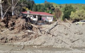
Houses on Joll Road in Havelock North were inundated with contaminated mud during Cyclone Gabrielle. Photo: RNZ/ Tess Brunton
Properties in Havelock North which flooded during Cyclone Gabrielle will again be deemed safe to live in, thanks to a $10 million flood protection plan.
More than 30 homes were damaged in February, when flooding inundated homes during Cyclone Gabrielle. They were then categorised 2C, meaning they were unsafe as-is to live in.
The funding comes as part of Hastings District Council's new strategy for the area's five dams and streams.
The council says the plan will reduce future risk in the areas which flooded during the cyclone, which should allow that area to be recategorised to category 1 by the Hawke's Bay Regional Council.
While the regional council was managing flood mitigation solutions for other affected areas across Hastings, in a deviation from the norm, Hastings District Council was responsible for Havelock North.
For projects related to the Mangarau Dam and stream, the council said it needed government funding, and their new strategy would help inform the business case for that.
Hastings mayor Sandra Hazlehurst said she knew it had been a long 10 months for the owners of flooded homes.
"Our three waters and recovery teams have been keeping those most affected in Havelock North updated, however I know that our broader community is also very interested in what needs to happen across the dams and streams."
Reports on the performance of the dams have been completed and are publicly available.
Another report, commissioned by the regional council on the Mangarau Stream, is still in draft and expected to be completed by the end of the month.
The recent dam report says the dams performed as designed, "throttling" the amount of water being released to reduce the impact on the village.
The amount of rain that fell in the area was 80 percent more than the previous record.
Modelling estimates that without the dam, water flow in the Mangarau Stream would have been another 22 cubic metres (or 22,000 litres) a second - that's 60 percent more than the actual flow recorded, which was 35 cubic metres a second.
Hazlehurst said while previous councils could not have envisaged a storm this size, "now that we have had an event of this significance, with serious outcomes, we need to prioritise work that will further reduce risk".