
A landslide is causing headaches for engineers on the Pūhoi-to-Warkworth highway. Photo: SUPPLIED / Waka Kotahi
The Auckland Anniversary floods have reactivated a landslide that now threatens a new $880 million motorway north of the city.
Open just a month, cracks have now appeared in concrete barriers, and an entire section may be moving under the Pūhoi-to-Warkworth highway.
Waka Kotahi has known for years the land in the area is unstable but thought the motorway would bypass it.
Instead, until-now undisclosed reports reveal the entire 18.5km-long project was beset by landslides for years, and the recent storms have made it worse, especially at one spot - an unstable slope above a stretch of about 200m of motorway by Mahurangi Bridge, near Warkworth.
It appeared "a pre-historical and deep-seated landslide has been reactivated" by January's massive rainfall, according to a report released to RNZ on Monday under the Official Information Act (OIA).
The "slope has experienced another landslide and is moving towards the carriageway" at a stop-start rate of sometimes more than 30cm a week, the 20-page external engineer's report to the agency said.
"Cracks have been reported in concrete barriers in two separate places on the western side of the carriageway.
"There is the potential that some landslide movement is occurring across the full width of the carriageway."
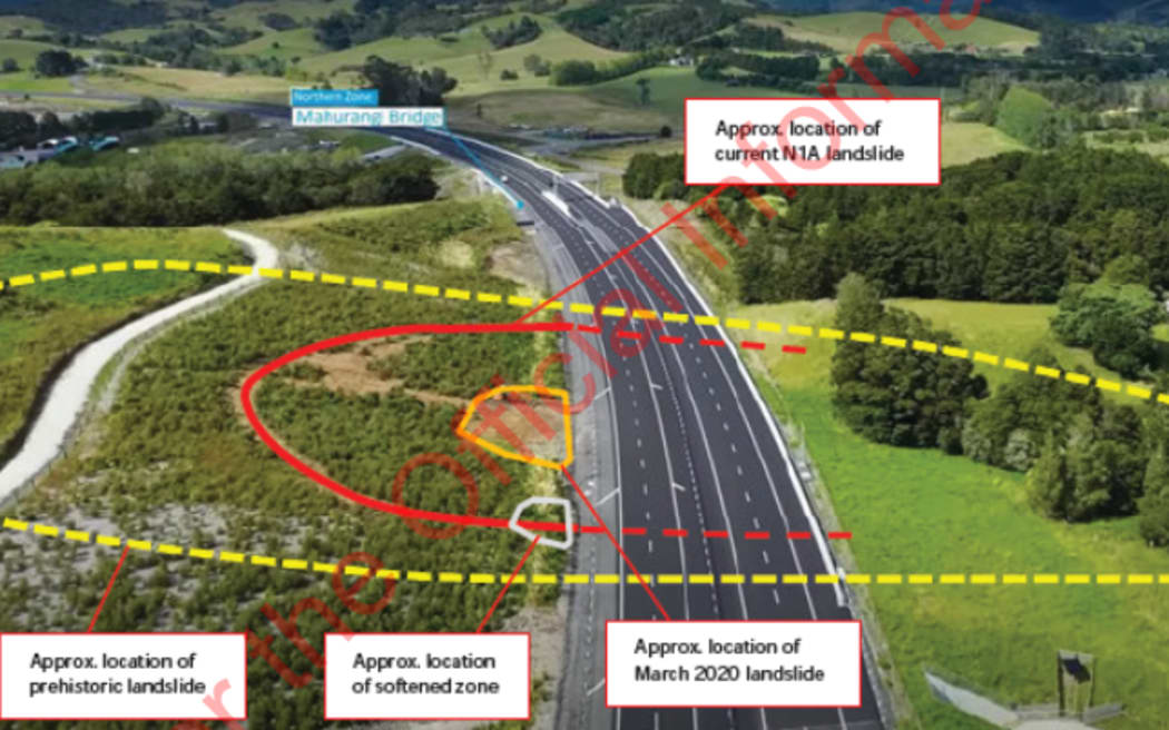
The landslide area shown in a Waka Kotahi report, marked onto drone image of the Pūhoi to Warkworth highway, which was captured in January by the highway builders NX2. Photo: Supplied/ Waka Kotahi/ NX2
This - and a second, 300-page report that revealed a risk from rockfalls - had forced emergency repairs at a road touted at its June opening by Prime Minister Chris Hipkins (from under a large umbrella) as a key to unlock the north, and by Waka Kotahi as a "safer, more resilient and reliable route".
Hipkins did not know at the time, but Waka Kotahi did, that already a large slope had begun sliding down toward the motorway at an average 5 to 11cm a week.
A noticeable bulge had developed at the toe of the slip at Mahurangi Bridge and the road's shoulder had been damaged, in just the few weeks between the floods and the 4 April report. The road surface might be forced upward, it said.
The report suggested the motorway's design was not up to scratch, as it was meant to last 100 years.
"It would be unreasonable for [builders] NX2 and the Independent Reviewer to state that the... cut slope and associated geotechnical elements have satisfied the design life requirements."
The second 300-page investigation in April, also newly released under the OIA, said the motorway construction project had been dealing with 19 landslides by late 2019.
"Slope failures continued to occur into late 2022, some of which are either under repair, or remedial work designs are yet to be confirmed."
RNZ earlier reported a 2020 resilience assessment for Waka Kotahi had said the land in the vicinity was "constantly moving but P2W [Pūhoi to Warkworth] will bypass".
Read the document: Waka Kotahi 2020 National Resilience Programme (21MB)
The assessment criticised the agency for "disjointed and reactive decision-making" that did not do enough to factor in climate change and resilience at many transport projects. This had led to "suboptimal and inefficient investment choices".
The 20-page report on the slip near Mahurangi Bridge identified "moderate risk" to the motorway width, and "high risk" to the cut slope and motorway shoulder that "is unacceptable without treatment".
"A quantitative risk assessment of the risk to persons (loss of life) has not been carried out," it said.
It was unlikely to fail rapidly, but "slow-moving landslides can cause high levels of financial loss, reputational damage and, in some cases, loss of life if not monitored closely".
"Unless stabilised, there remains uncertainty and a risk of the landslide movement accelerating or becoming more significant, especially if more extreme rainfall events are experienced," said the report, by authors GHD and Jacobs.
They told Waka Kotahi it needed to find out a lot more about the landslide from the construction consortium, NX2.
The agency told RNZ on Monday it had taken measures to "ensure the landslide poses no risk to the public travelling on the motorway" by putting concrete barriers in place.
NX2 had come up with a solution and begun stabilising work that would run until October.
A second slope, 30m long by 4m wide, had also been cut too steep, and landslips hit this section during heavy rain in July 2022 and January 2023. The cut had to be flattened out, the transport agency said.
The Pūhoi landslide reveal came at the same time the National Party was pledging to spend $500m over three years fixing potholes, by taking money away from speed-reduction initiatives, like median barriers.
Along the motorway, independent risk assessments done for NX2 of 98 cuts through slopes scored them all at moderate risk or lower; most were at very low risk (51 of them).
But some were getting worse as water built up, and it was not certain the fixes would work, said the report.
"There could be a perceived optimistic assurance that these cut slopes have no future risk of landslides.
"Geology and ground conditions are not fully understood and the design solution may not be suitable at the cut slope" at some cuts, it said.
It identified four "high-risk" locations for rockfall, and these were fixed.
Waka Kotahi told RNZ the landslide remedial work would undergo independent review, certification and testing.
A few other localised cuts were marginally steeper than they should be, such as where natural features were incorporated, but they had all been assessed as OK, it said.
After RNZ reported in May about the 2020 resilience report that found more than 350 risks to the national roading network, the Minister of Transport Michael Wood said some roads may need to be abandoned as a result of climate change.
A geotechnical engineer familiar with roading failures said the motorway's builders should have known they were in a historical slip area.
"These types of failures, whilst unwanted, are not uncommon and can be difficult to detect," the engineer, who RNZ agreed not to name, said on Tuesday.
"However, good pre-build investigation should have identified the location as an historic landslip area."
Inquiries into the cause needed to look at what work went on uphill.
"There should not have been anything done there that could have compromised the slope's stability", he said by email.
"Other than avoiding that location or removing the material (both not now possible), engineering a well-designed piled retaining wall seems to be a sensible approach."
Construction methods criticised
A farmer who farmed the land the landslide is on said the builders appeared to dump excess spoil on top of the slope.
But the project's director up until June said they were replacing weak soil with rock at the time, and never did any work that destabilised the slope.
"We have known about it for some time, we have been monitoring it," said Robert Jones of the landslide. "It isn't something that surprised or particularly concerned us."
The road is a public-private partnership (PPP). Transmission Gully motorway was also a PPP and resulted in large cost overruns, with Waka Kotahi pursuing contractors for millions over delays.
Farmer and architect Denise Civil had ownership of land either side of the P2W motorway, some of which was acquired under the Public Works Act, in a process she said was badly handled by Waka Kotahi and was still dragging on for the next stage of the motorway to Wellsford.
Civil was emailed last November by NX2 project director Jones.
"After the recent heavy rainfall we have observed some movement to the slope to the south of the underpass and on the eastern side of the motorway," he wrote.
"To investigate this further we will need access onto your property to assess what is the problem and any potential stabilisation measures."
Civil told RNZ heavy rain alone could not be blamed.
"We believe that it was not only the rain that contributed to the recent slumping. During construction NX2 used the hill above the slip as a dump area for excess spoil.
"This would have loaded the hill and contributed to the problems now faced. Although not a geotechnical engineer, commonsense would suggest that this was not a good idea in an area known for its land instability."
But Jones, who retired last month from NX2, said the methodology was to take out weak soil and replace it with stronger rock, and this was what Civil may have seen.
"That's the process was followed."
The surrounding terrain nearby, but not associated with the road, also had a lot of landslides, he said.
"It's just a fact of life. It's something that has to be dealt with."
But Civil said there was an "area of top soil and rubbish" on Kauri Top, their name for the paddock they used to farm.
RNZ aims to report further on the Pūhoi-to-Warkworth motorway landslide risks later this week.