
The Little Girl is going away, and the Little Boy has arrived. It's been confirmed that we've seen the last of that very wet La Nina weather pattern, and El Niño has now begun in the Pacific Ocean. The El Niño Southern Oscillation, or ENSO, has three different phases: Hot, cold or neutral. El Niño is the hot one. It's the most powerful climate fluctuation anywhere on Planet Earth.
MetService rural meteorologist Georgina Griffiths told Sunday Morning global headlines had warned it could push the world into experiencing its warmest year on record in 2024.
But Griffiths said El Niño impacted regions around the world differently - either making it cold and wet or hot and dry.
"It depends where you are," Griffiths said.
"In our local region, Australia would see heat, drought and fires as we trend towards summer. We would see some parts of the southwest Pacific, so Papua New Guinea, Vanuatu, New Caledonia, Fiji, getting drier and the central and eastern Pacific maybe getting a wee bit wetter.
"For New Zealand, because we have such great mountains, those Southern Alps in the central plateau, it depends on which part of New Zealand you live in as to what impacts."
She said El Niño might not be very recognisable this winter but the "hallmark" El Niño response in New Zealand was a cold spring.
"We would expect a lot more southerlies than typical in spring for New Zealand.
"We are going to notice it after several years of heat."
By the time summer arrived, Griffiths said enhanced or frequent westerly winds could be expected across the country.
The east coast of both islands could expect heat, dryness or drought and the heightened risk of fires.
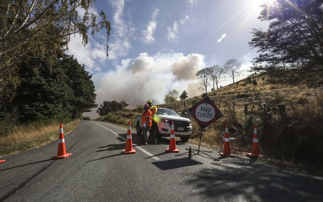
There will be a heightened risk of bushfires as El Niño takes hold, a meteorologist says. Photo: RNZ / Rebekah Parsons-King
Meanwhile, the western areas of both islands could expect a summer that was cloudier, cooler, windier and a bit wetter.
This year's El Niño has arrived early, Griffiths said.
"Typically we would get the peak of the El Niño around Christmas time, it's named for that, and we would have increasing awareness of the impacts here in New Zealand by around Christmas or just after, and importantly for people globally, this El Niño has a decent chance of being a very strong El Niño."
Not affected by El Niño but by deep lows coming from the Southern Ocean, Griffiths said people would also be in shock this winter.
Snow had already fallen in the South Island, which was "good news" for the ski season.
"I think most people will be in for a bit of a shock this winter. Temperatures are running a lot closer to average and it's been a long time since we even had an average winter because it's been warm the last few years. We are already running cooler than we have for many a year and we've forgotten what winter cold is.
"We are not used to cold winters anymore. We have forgotten in the last four-five years but yeah, might be one of those winters we're actually grabbing out some of the coats we haven't seen in a while."
As New Zealand moved towards spring, Griffiths recommended people keep an eye on MetService for the latest forecasts.

